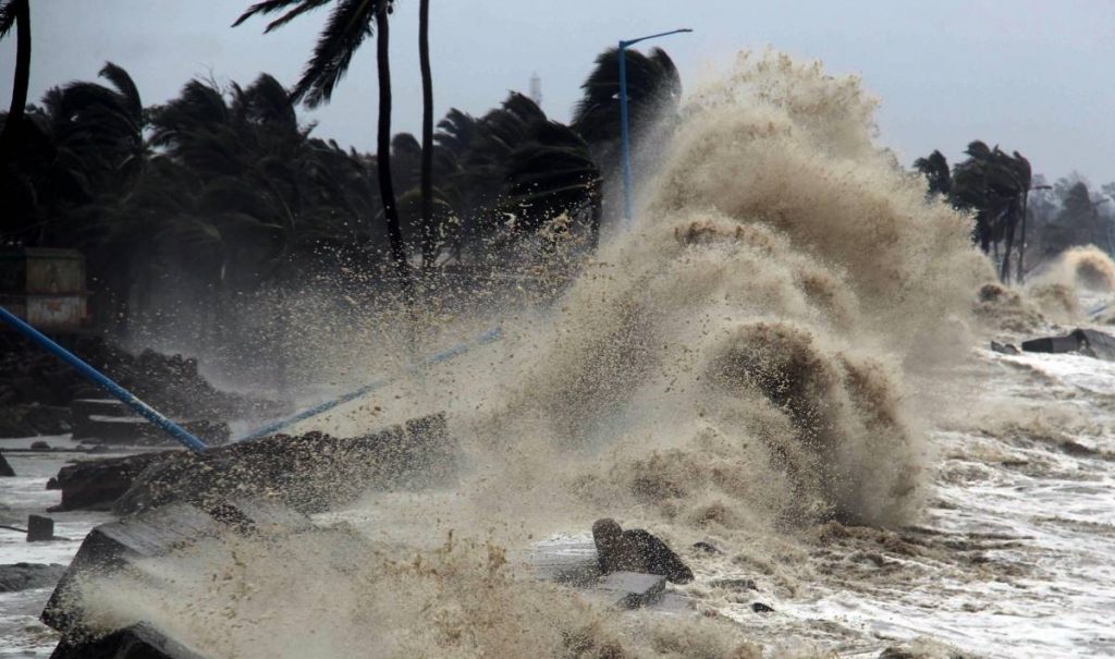
The cyclone is likely to impact Srikakulam, Vizianagaram and Visakhapatnam districts in north coastal Andhra….reports Asian Lite News
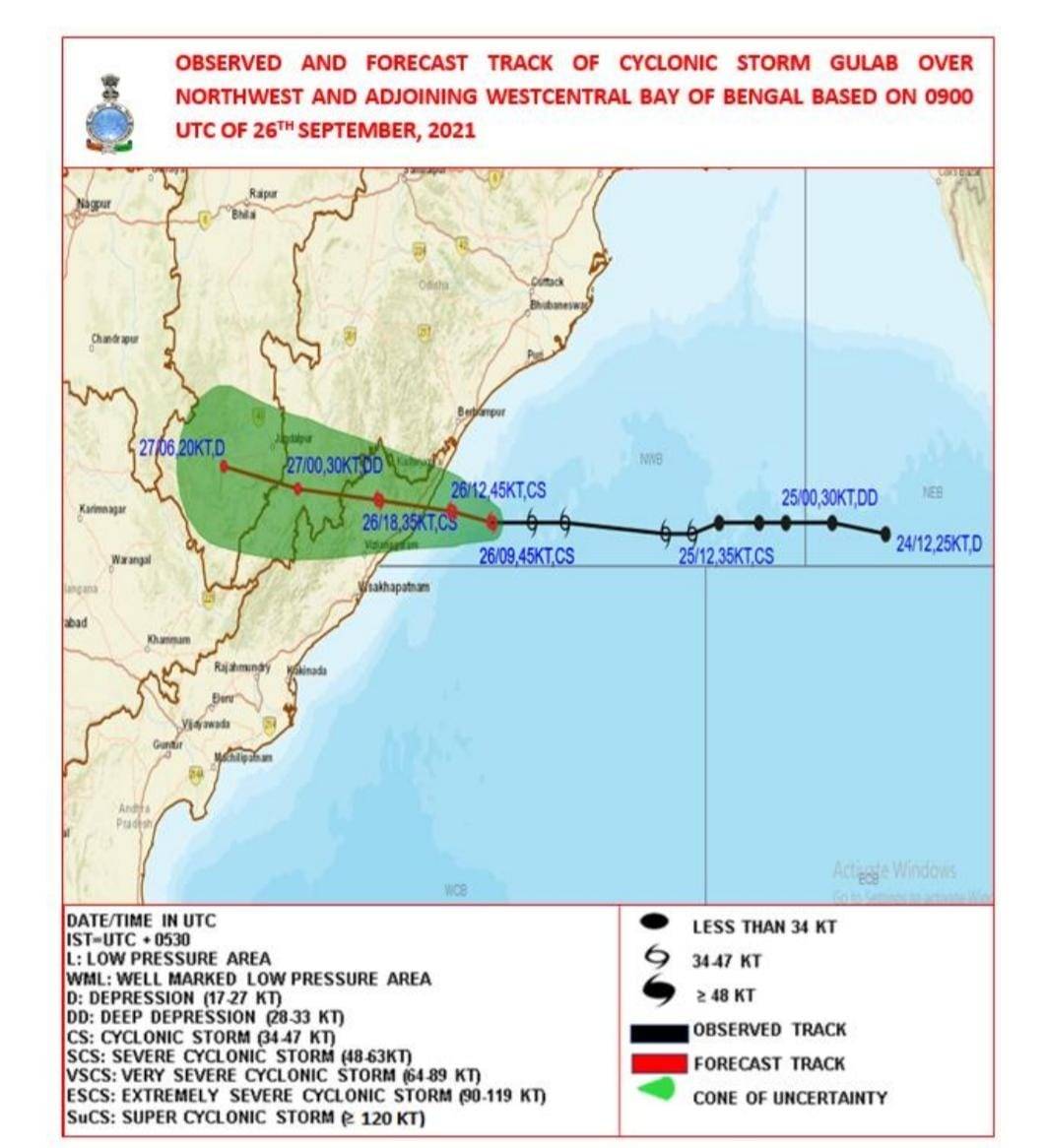
Cyclone ‘Gulab’ started making landfall on Sunday evening, triggering heavy rains along with strong winds over north coastal Andhra Pradesh and adjoining south coastal Odisha.
The landfall process commenced around 6 p.m. between Kalingapatnam in Andhra Pradesh and Gopalpur in Odisha as the cloud bands entered the coastal region. The process will continue for next two to three hours, said the India Meteorological Department (IMD).
The cyclone is likely to impact Srikakulam, Vizianagaram and Visakhapatnam districts in north coastal Andhra.
In Srikakulam district, authorities evacuated 1,100 people from low-lying areas and shifted them to 61 relief centres.
Two teams of National Disaster Response Force (NDRF) and four teams of State Disaster Response Force (SDRF) have arrived in the region as the meteorologists have warned that heavy rainfall could lead to floods.

The entire coastal region has been put on alert in view of the impact of cyclone. The district administration have opened control rooms monitor the situation.
Prime Minister Narendra Modi spoke to Andhra Pradesh Chief Minister Y.S. Jagan Mohan Reddy and took stock of the situation arising in the wake of cyclone. The PM tweeted that he assured all possible support from the Centre. “I pray for everyone’s safety and well-being,” Modi wrote
Indian naval ships and aircraft are on standby for rescue and relief operations in the areas likely to be affected by the cyclone.
The Navy is closely monitoring the movement of the cyclonic storm. Headquarters, Eastern Naval Command, and Naval Officers-in-Charge Odisha area have carried out preparatory activities to combat the effects of cyclone and are in constant liaison with the state administrations for rendering assistance as required, an official release said.
As part of the preparedness, flood relief teams and diving teams are positioned at Odisha and are ready at Visakhapatnam to render immediate assistance.
Two naval ships are at sea with Humanitarian Assistance and Disaster Relief (HADR) material and medical teams to render assistance in the most affected areas. Naval aircraft are kept ready t Naval Air Stations, INS Dega at Visakhapatnam and INS Rajali near Chennai to undertake an aerial survey of the most affected areas, casualty evacuation, and airdrop of relief material as required.
Earlier, the Cyclone Warning Centre, Visakhapatnam warned that tidal wave of about 0.5 m height above the astronomical tide likely to inundate low lying areas of Srikakulam, Vizianagaram, and Odisha’s Ganjam districts during the time of landfall.
The cyclonic storm is likely to trigger heavy rains at one or two places over Srikakulam, Vizianagaram and Visakhapatnam districts over the next 24 hours. The IMD has issued red warning for these districts.
Heavy to very heavy fall at a few places is very likely over East Godavari, West Godavari districts, and Yanam. Heavy rainfall very likely to occur at one or two places over south coastal Andhra Pradesh, the IMD bulletin said.
Squally wind speed reaching 45-55 kmph gusting to 65 kmph likely to prevail along and off north Andhra Pradesh coast. It will gradually increase becoming gale wind speed reaching 75-85 kmph, gusting to 95 kmph, from afternoon of September 26 till midnight along and off north Andhra Pradesh (Srikakulam, Vizianagaram and Visakhapatnam districts). Squally wind speed reaching 40-50 kmph gusting to 65 kmph likely to prevail over remaining districts of coastal Andhra Pradesh.
As sea condition will be rough to very rough, fishermen have been advised not to venture into sea till September 27.
Local cautionary signal- III was hoisted at Visakhapatnam, Gangavaram and Kakinada ports. Distant warning signal-II was hoisted at Machilipatnam, Nizampatnam and Krishnapatnam ports.
Strong winds and very heavy/extremely heavy rainfall are likely to damage thatched huts, cause minor damage to power and communication lines due to breaking of branches and uprooting of trees, cause major damage to Kutcha and minor damage to pucca roads, some damage to paddy crops, banana, papaya trees and orchards, and there could be sea water inundation in low-lying areas after erosion of embankments, localised flooding of roads, inundation and water-logging in low-lying areas and closure of underpasses mainly in urban areas of the region.
In Bhubaneswar, Met Centre scientist U.S. Das said that the cyclone will have major impact on Ganjam and Gajapati districts of Odisha.
Besides, districts like Rayagada, Malkangiri, Koraput, and Nabarangpur would also witness heavy windfall of 55-65 kmph gusting to 75 kmph, Das added.
“We are in touch with the district administrations of Rayagada, Gajapati, Ganjam and Koraput. So far, we have not received any info about heavy rainfall or windfall in those districts. However, low to medium rainfall activity has started in Gajapati district,” said Special Relief Commissioner P.K. Jena.
As per the report, till afternoon, over 16,000 people have evacuated from low-lying and vulnerable areas, he said.
About 600 pregnant, old, and disabled people have also been shifted to safe shelter or hospitals in the likely affected districts, Jena said. “We expect that the system will cross Odisha by tomorrow (Monday) forenoon,” he added.

Leave a Reply