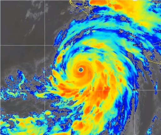
The storm is forecast to begin weakening on Saturday as it encounters cooler water temperatures and then become a tropical storm by Sunday as it approaches the US…reports Asian Lite News
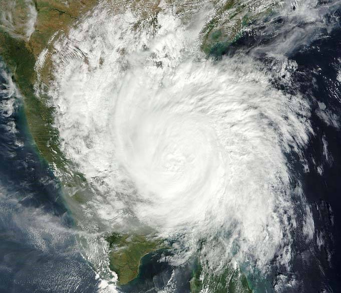
Hurricane Hilary strengthened to Category 4 early Friday and is expected to weaken as it barrels toward the US state of California.
The US National Weather Service tweeted that the storm would “lead to significant impacts” to the southwestern US this weekend into early next week, with rainfall totals of 3 to 6 inches and isolated amounts of up to 10 inches for parts of southern California and southern Nevada.
Within 24 hours, Hilary has rapidly intensified from a 70 mph tropical storm to a “large and powerful” 140 mph Category 4 hurricane as of early Friday, Xinhua news agency reported, citing the National Hurricane Center.
The storm is forecast to begin weakening on Saturday as it encounters cooler water temperatures and then become a tropical storm by Sunday as it approaches the US.
Weekend flood watches have been issued across southern California, stretching from San Diego to Los Angeles. The National Weather Service in Los Angeles has also warned of the potential for dangerously high surf, rip currents and coastal flooding.
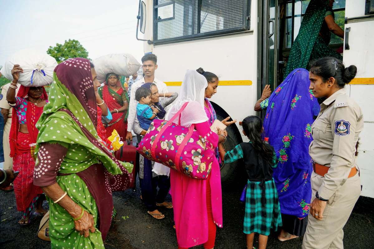
People being evacuated from villages to shelter in view of the impending Cyclone Biparjoy, at Jakhau in Kutch on Wednesday. (ANI Photo)
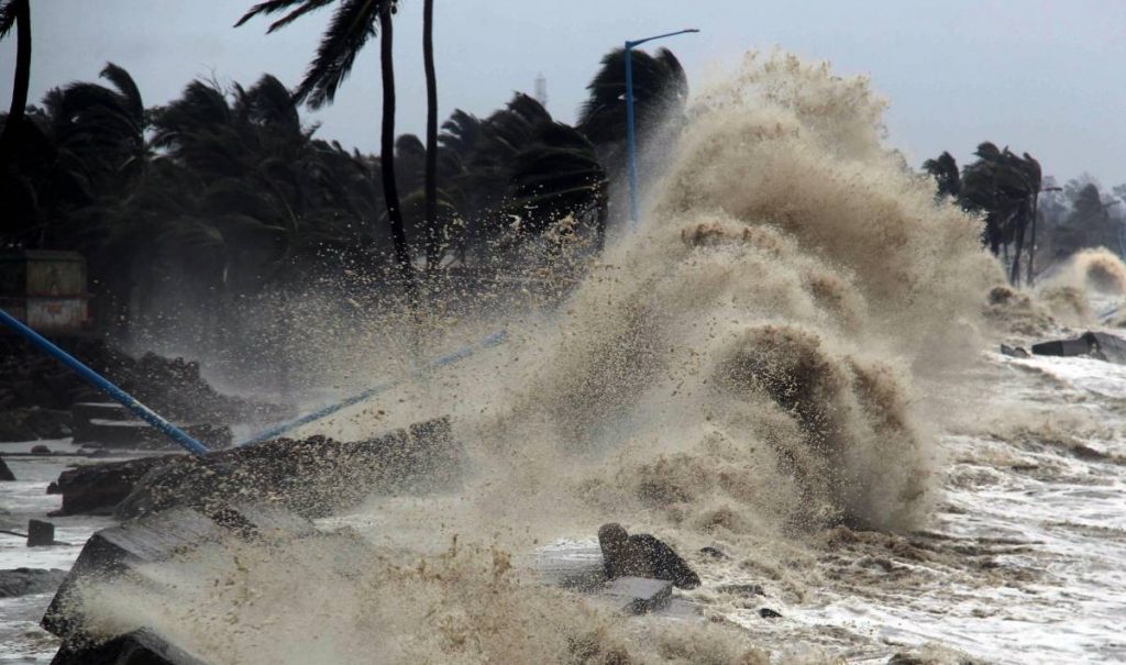
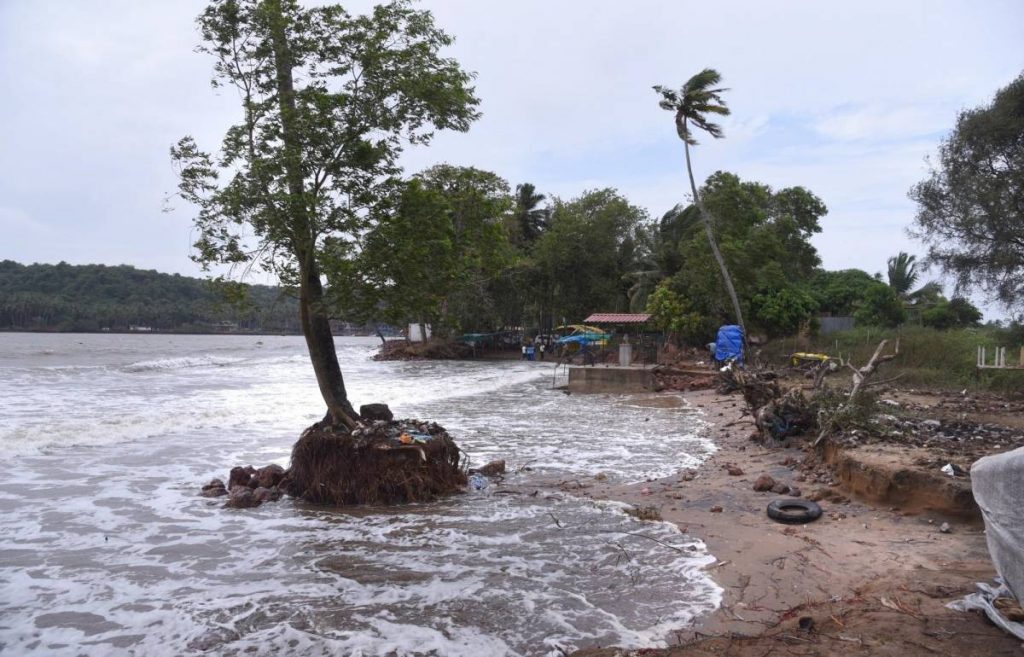
Under the influence of the severe cyclonic storm Biparjoy, high tidal waves hit Gujarat on Thursday….reports Asian Lite News
As cyclone Biparjoy has hit several parts of Gujarat, Kachchh’s Mandvi, on Thursday, witnessed rough sea conditions and strong winds.
Earlier, the Indian Meteorological Department, on Sunday, gave a cyclone alert for Saurashtra and Kutch coasts in Gujarat. The department issued the alert: “Cyclone alert for Saurashtra and Kutch coast: Yellow message, ESCS BIPARJOY over East-central Arabian sea, at 1730 IST of 11th June near lat 18.6E and long 67.7E, likely to cross between Mandvi (Gujarat) and Karachi (Pakistan) by noon of 15th June”.
Also, under the influence of the cyclone, high tidal waves hit Gujarat, on Thursday. According to the IMD, VSCS (very severe cyclonic storm) Biparjoy is to cross Saurashtra & Kutch & adjoining Pakistan coasts b/w Mandvi & Karachi near Jakhau Port by the evening of June 15.
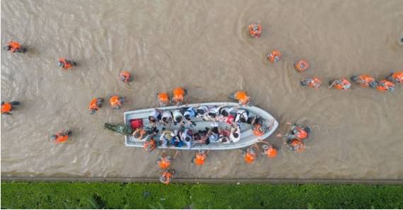
Amreli, June 14 (ANI): A team of 108 along with Pipavav Marine Police conduct a rescue operation of a pregnant woman who was bought to Pipavav port jetty via boat from Shiyalbet, in Amreli on Wednesday. All boat services have been stopped to go to Shiyalbet, only emergency boat service has been started. (ANI Photo)
In addition to this, ahead of the cyclone, National Disaster Response Force (NDRF) and State Disaster Response Force (SDRF) were deployed in the state, on Wednesday.
“NDRF and SDRF have been deployed in Kachchh’s Mandvi and Naliya town which is likely to be affected as cyclone BIPARJOY is getting closer”, said Naliya Police sub-inspector VR Ulva.
The weather department also mentioned the chances of heavy damage in the Arabian Seas.
“There is a possibility of heavy damage due to the cyclonic storm BIPARJOY”, said IMD. Also, authorities, on Tuesday, shifted around 30,000 people from coastal areas to temporary shelters considering Biparjoy’s possible landfall near Jakhau’s port in Gujarat’s Kutch district.
“Because of the cyclone, Mandvi and Naliya are declared hotspots. We have made the public aware of the disaster The SDRF team is deployed for Ghnateshwar, Rajkot. The NDRF team has been deployed. The teams will be in direct contact with the DSP and SP Vaghela of Naliya Police. We will remain on alert and run the rescue operation as and when needed”, said Ulva, Police Sub-inspector, Naliya.
Damage expected over 7 districts of Gujarat The India Meteorological Department (IMD) on Wednesday said that damage is expected over Kutch, Devbhumi Dwarka, Porbandar, Jamnagar, Morbi, Junagarh and Rajkot districts of Gujarat on June 15.
The IMD further predicted that sea condition will be phenomenal over northeast Arabian Sea till June 15 evening and rough to very rough over adjoining east central Arabian Sea during the same period.
“Along and off Saurashtra and Kutch coasts the sea condition is likely to be very rough till June 14 evening and high to phenomenal thereafter till June 15 evening and would improve thereafter,” said IMD while issuing storm surge warning for Kutch, Devbhumi Dwarka, Porbandar, Jamnagarh and Morbi districts.
“The astronomical tides along these districts could be up to 3-6 meters in different places and damage expected in these districts on June 15,” said an IMD official.
The IMD further predicted that the intensity of rainfall would increase with heavy to very heavy rainfall at a few places and extremely heavy falls at isolated places very likely over Kutch, Devbhumi Dwarka and Jamnagar and heavy to very heavy rainfall at a few places over Porbandar, Rajkot, Morbi and Junagarh districts of Gujarat.
“Isolated heavy to very heavy rainfall is very likely over remaining districts of Saurashtra and north Gujarat region on June 15 while light to moderate rainfall at most places with heavy to extremely heavy rainfall at isolated places very likely over north Gujarat and adjoining south Rajasthan on June 16 and southeast Rajasthan and adjoining North Gujarat region on June 17,” said the IMD official
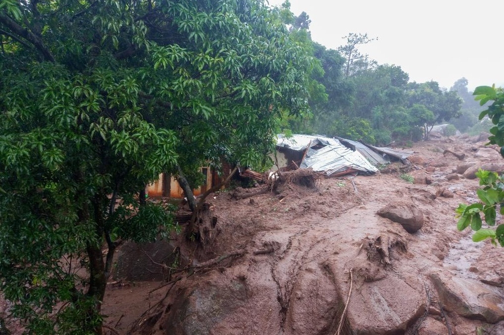
Photo taken on March 13, 2023 shows a house damaged by Tropical Cyclone Freddy in Chilobwe, Blantyre, Malawi. (Photo by Joseph Mizere/Xinhua/IANS)
Cholera is also spreading in Mozambique. But, there are not enough water disinfection supplies to support containment activities to control the outbreak, OCHA said…reports Asian Lite News
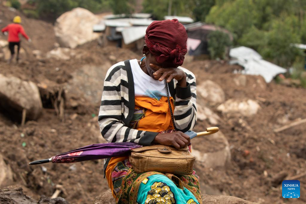
Malawi authorities assessing the rising devastation of cyclone Freddy report more than 500,000 people affected, including at least 326 people killed, UN Humanitarians said.
The government reports 442 people rescued during search and rescue operations on Thursday alone, the UN Office for the Coordination of Humanitarian Affairs (OCHA) said. More than 180,000 people are homeless.
The government-led relief efforts expand as flood waters recede, and the focus is on reaching displaced people, the office said.
“However, some areas remain cut off due to the extremely challenging conditions on the ground,” OCHA said. “Aid workers are mobilising air transport and boats to transport supplies and search and rescue efforts in locations that can’t be accessed by road.”
The office said that humanitarian partners are concerned about the risk of cholera spreading in flood-affected areas, especially in crowded displacement sites.
The UN Children’s Fund (UNICEF) and its partners are working to clean latrines in schools serving as shelters in Blantyre and will also install water storage bladders to provide safe drinking water.
The OCHA said that in Chikwawa, one of the districts with the highest number of displaced people, the World Food Programme and its partners distributed super cereal, a blend of corn and soy, to all displacement sites. Similar efforts are underway in other districts.
In neighboring Mozambique, the number of people affected by Freddy’s second landfall also continues to rise, reaching 340,000, UN humanitarians said. With the cumulative impact of floods and two landfalls of Freddy, more than 510,000 people were affected across Mozambique.
Cholera is also spreading in Mozambique. But, there are not enough water disinfection supplies to support containment activities to control the outbreak, OCHA said.
The UN team has a presence in each of the cyclone-affected provinces in Mozambique, the office said. “We are working closely with the authorities to provide aid to over 49,000 people displaced and to access areas isolated by floods.”
The office said that humanitarian partners are finalising a flash appeal – as an addition to this year’s overall appeal – to address the most urgent humanitarian needs resulting from the convergence of Freddy, floods and cholera.
On Thursday, the UN Central Emergency Response Fund released $10-million to help address some relief gaps. Still, OCHA said more funds are urgently needed.
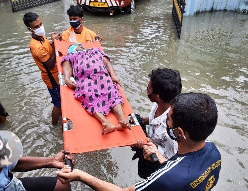
Indian Navy join the rescue and relief mission at flood hit villages in Kerala
The report shows that every part of Asia was affected in 2020, from the Himalayan peaks to low-lying coastal areas, from densely populated cities to deserts and from the Arctic to the Arabian seas….reports Asian Lite News
Last year in Asia, tropical cyclones, floods and droughts induced an estimated average annual loss (AAL) of several hundred billion dollars, with a latest report from the World Meteorological Organization (WMO) estimating the losses at approximately $238 billion in China, $87 billion in India and $83 billion in Japan.
As per the UN Economic and Social Commission for the Asia and the Pacific (ESCAP) estimate, the average annual loss is expected to be as high as 7.9 per cent of GDP ($7.5 billion) for Tajikistan, 5.9 per cent of GDP ($24.5 billion) for Cambodia and 5.8 per cent of GDP ($17.9 billion) for the Laos, the WMO ‘State of the Climate in Asia 2020’ report said on Tuesday.
Even when the highest AALs are associated with drought, the floods and storms affected approximately 50 million people and resulted in more than 5,000 fatalities in 2020, below the annual average of the last two decades of 158 million people affected and about 15,500 fatalities, the WMO said and added: “This is a testimony to the success of early warning systems in many countries in Asia.”
The report also said that the true impacts of Covid-19 on food security and nutrition are yet to be established.
“But compared with 2019, the number of undernourished people in 2020 increased by 6 per cent in South-East Asia and West Asia, and by 20 per cent in South Asia. Climate-related disasters compounded the problem,” it said in the report.
The report shows that every part of Asia was affected in 2020, from the Himalayan peaks to low-lying coastal areas, from densely populated cities to deserts and from the Arctic to the Arabian seas.
“Weather and climate hazards, especially floods, storms, and droughts, had significant impacts in many countries of the region, affecting agriculture and food security, contributing to increased displacement and vulnerability of migrants, refugees, and displaced people, worsening health risks, and exacerbating environmental issues and losses of natural ecosystems,” said WMO Secretary General Professor Petteri Taalas.
The report provides an overview of land and ocean temperatures, precipitation, glacier retreat, shrinking sea ice, sea level rise and severe weather. It examines socio-economic impacts in a year when the region was also struggling with the Covid-19 pandemic, which in turn complicated disaster management.
“Combined, these impacts take a significant toll on long term sustainable development, and progress toward the UN 2030 Agenda and Sustainable Development Goals in particular,” he said.
“Amidst the pandemic, countries are hit by a range of disasters and have to deal with the increasingly damaging impacts of climate change,” said ESCAP Executive Secretary, Armida Salsiah Alisjahbana.
“Fewer than 10 per cent of the SDG targets are on track to be achieved by 2030. The most alarming are regressing trends on climate action (Goal 13) and life below water (Goal 14): both of which are related to disaster resilience.”
The report also mentioned, in 2019, approximately three fourths of mangroves in Asia were located in Bangladesh (24 per cent), Myanmar (19 per cent), India (17 per cent) and Thailand (14 per cent) and how mangroves in Bangladesh, a low-lying state, were exposed to tropical storms and decreased by 19 per cent from 1992 to 2019.
Forests absorb carbon dioxide and are an important carbon sink. Between 1990 and 2018, Bhutan, China, India, and Vietnam increased their forest cover. But forest cover declined in Myanmar (26 per cent), Cambodia (24 per cent) and the Democratic People’s Republic of Korea (12 per cent), it said.
A positive thing that the report pointed out was that Asia is currently well placed to respond to extreme weather events and is among the regions with the greatest capacity for Multi-Hazard Early Warning Systems (MHEWS).
“But the costs of extreme events are rising, due in part to increasing exposure. A high proportion of existing critical infrastructures are in multi-hazard risk hotspots, which can lead to significant disruption in economic activity when natural disasters occur. For instance, about a third of energy power plants, fibre-optic cable networks and airports, and 42 per cent of road infrastructure, are in multi-hazard risk hotspots in the Asia-Pacific,” it said.
Also, increased heat and humidity are forecast to lead to an effective loss of outdoor working hours, with a potential cost of many billions of dollars, the report added.
Cyclone Amphan, one of the strongest ever recorded, hit the Sundarbans region between India and Bangladesh in May 2020, displacing 2.4 million people in India and 2.5 million people in Bangladesh.
“Many a weather and climate-related displacements in Asia are prolonged, with people unable to return home, integrate locally or settle elsewhere,” it said.
The report combines input from a wide range of partners including the ESCAP and other UN agencies, national meteorological and hydrological services as well as leading scientists and climate centres.
It was published by WMO ahead of the UN Climate Change Conference, COP26, as one of a series of regional analyses to inform decision makers and policy makers as well as regional and national investment.
Conditions are becoming favourable for further withdrawal of the southwest monsoon from some more parts of Gujarat, Chhattisgarh..reports Asian Lite News
Even as conditions have become favourable for further withdrawal of southwest monsoon from large parts of northwest India, two cyclonic circulations in the Arabian Sea and the Bay of Bengal each will bring in heavy rainfall in much of central and peninsular India over next two days, the IMD said on Sunday.
Conditions are becoming favourable for further withdrawal of the southwest monsoon from some more parts of Gujarat, Chhattisgarh, most parts of Madhya Pradesh, Jharkhand, Bihar, and some parts of Maharashtra, Odisha and West Bengal during next two days, the India Meteorological Department (IMD) said in a statement.
The first cyclonic circulation lies over north Andaman Sea and its neighbourhood. Under its influence, a Low Pressure Area is very likely to form over the same region during next 36 hours. It is likely to become more marked and move west-north-westwards towards south Odisha-north Andhra Pradesh coasts during subsequent 4-5 days, the IMD said.
“Under its influence, light to moderate rainfall at most places with isolated thunderstorm (wind speed 40-50 kmph gusting to 60 kmph) and heavy to very heavy rainfall is very likely over Andaman and Nicobar Islands during next 5 days,” it added.
A cyclonic circulation also lies over east central Arabian Sea and extends up to mid tropospheric level tilting south-westwards with height. It is very likely to persist during next 3-4 days, and under its influence, fairly widespread to widespread light to moderate rainfall with isolated heavy rainfall is very likely over southern peninsular India during next 5 days and over Maharashtra during next two days.
Isolated very heavy rainfall is very likely over Kerala and Mahe between October 12 and 14, the IMD release said.
The withdrawal of southwest monsoon commenced very late on October 6 this year as against the normal date of September 17.
Sharjah Crown Prince praises efforts to prepare for 'Shaheen'
The work teams had shown high professionalism in developing proactive plans to deal with crises to save lives and reduce potential damage…reports Asian Lite News
Sheikh Sultan bin Mohammed bin Sultan Al Qasimi, Crown Prince and Deputy Ruler of Sharjah and Chairman of Sharjah Executive Council (SEC), praised the concerted efforts of the work teams in government agencies, lauding their readiness and preparedness to face crises, especially in dealing with tropical cyclone “Shaheen”.
He stressed that the work teams had shown high professionalism in developing proactive plans to deal with crises to save lives and reduce potential damage.
H.H. Dr. Sheikh Sultan bin Muhammad Al Qasimi, Supreme Council Member and Ruler of Sharjah
He said this during the meeting of the Sharjah Executive Council chaired by Sheikh Sultan, which was held on Tuesday morning at the Ruler’s Office, in the presence of H.H. Sheikh Sultan bin Ahmed bin Sultan Al Qasimi, Deputy Ruler of Sharjah.
On Teacher’s Day, the Crown Prince thanked all the teachers, on the occasion of Teachers’ Day, appreciating their vital role in building societies by educating the generations and graduating batches of intellectuals and specialists in all fields.
He praised the role of workers in the educational system, including teachers, administrators and assistants, and their efforts in dealing with the COVID-19 pandemic and the rapid transformation of distance learning and adapting to all its cases.
The council has further discussed several topics on its agenda related to developing government work, providing the emirate with the best services and vital facilities, and raising the standard of decent living for Sharjah residents.
As part of the continuous development of the infrastructure sectors and in conjunction with the comprehensive development in the emirate, the council approved the smart traffic control project to develop the traffic light system in the emirate using the latest technologies and international systems in the field of traffic.
This will facilitate traffic flow by checking and identifying traffic jams, prioritising traffic and reducing waiting time by up to 20 percent.
The new project will also make traffic smoother, increase safety levels, reduce collisions, cut pollution levels by reducing carbon emissions from the traffic stops.
Sharjah Crown Prince praises efforts to prepare for ‘Shaheen’
The council reviewed the report on the performance of the general budget and the outputs of activities for the second quarter of 2021 submitted by the Central Finance Department to follow up the performance of the general budget and work to develop it and improve its aspects and outputs.
The report included graphic indicators of the general budget and tables comparing revenues and expenditures for the second quarter of 2021 for government agencies and independent bodies in the emirate.
The report also included the actual spending ratios for each sector of social development, government administration, infrastructure and economic development.
The council approved the list of candidates for the sixth batch of the professional diploma for child protection, which comes in cooperation between the Social Services Department and the University of Sharjah.
The professional diploma programme contributes to developing the skills of graduates working in child protection and benefitting from the programme’s outputs to deal with modern social phenomena and situations.
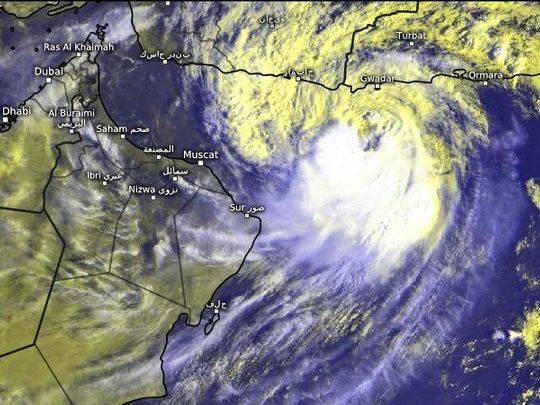
Tropical Cyclone Shaheen killed at least three people as it slammed into Oman..reports Asian Lite News
Tropical Cyclone Shaheen killed at least three people as it slammed into Oman on Sunday with ferocious winds and heavy rain, flooding streets, prompting evacuations from coastal areas and delaying flights to and from the capital, Muscat.
As the cyclone approached, a child who had been swept away by water was found dead, the state news agency said, and another person was missing. Two Asian workers were killed when a hill collapsed on their housing area in an industrial zone, the state news agency reported.
oman
When its eye crossed land, the cyclone was carrying winds of between 120 and 150 km per hour (75-93 mph), Omani authorities said. It was throwing up waves of up to 10 metres (32 feet).
Video footage from Omani broadcasters showed vehicles submerged as people tried to make their way through muddy brown floodwater.
Part of the eyewall of the storm, where the most severe weather occurs, had entered Al Batinah South governorate, the state news agency said. The eye also entered between the states of Musanah and Suwaiq.
Massive rainfall of as much as 500 cm (20 inches) was expected in some areas, potentially causing flash floods.
Cyclones steadily lose their power once they stop travelling over ocean waters and Shaheen was downgraded to a tropical storm after it had hit land, the local meteorology service said in a tweet.
The national emergency committee said the power supply would be cut in al-Qurm, east of the capital, to avoid accidents.
More than 2,700 people were put up in emergency shelters.
Most of the oil-exporting country’s five million people live in and around Muscat. Authorities said roads in the capital would be open only to vehicles on emergency and humanitarian journeys until the storm dies down.
A wooden ship sank at Sultan Qaboos Port and its crew was rescued, said the National Committee for Emergency Management in a tweet.
Precautions in UAE
In the United Arab Emirates, authorities said precautionary measures were being taken. Police officials were moving to ensure safety by conducting security patrols near beaches and valleys where torrential rains were expected.
Government and private sector employees in the city of Al Ain on the border with Oman have been urged to work remotely on Monday and authorities called on residents to avoid leaving home except for emergencies, the Abu Dhabi Government Media Office said.
“Authorities are working proactively around the clock to evaluate residential units in expected affected areas and transport families to safe locations until it is safe to return,” it said.
Saudi Arabia’s civil defence authorities called for caution in several regions from Monday to Friday in expectation of high winds and possible flooding, the state news agency reported.
The findings revealed the possible linkage of La Nina years with increased severity of tropical cyclones…reports Asian Lite News
Reporting an increased amount of water vapor content in the troposphere, a new study by Indian scientists has reiterated that the intensity of severe cyclonic storms in the North Indian Ocean region has shown an increasing trend in the past four decades.
The scientists studied the role and influence of critical atmospheric parameters in large-scale environmental flow and El Nino-Southern Oscillation (ENSO) on tropical cyclone activity in the North Indian Ocean and investigated the role of additional parameters such as water vapor and zonal sea level pressure gradients.
The findings revealed the possible linkage of La Nina years with increased severity of tropical cyclones.
“The study reported an increased amount of water vapor content in the troposphere, at 1.93 times during the past 38 years as compared to the base year 1979,” a release from the Ministry of Science and Technology said on Thursday.
During the past two decades (2000-2020), the La Nina years experienced almost double the number of intense cyclones compared to the El Nino years.
Besides, during the La Nina years, the positional shifts in average cyclogenesis of intense cyclones in Bay of Bengal have been analogous with the observations for the Western North Pacific Ocean basin.
According to meteorologists, El Nino, Spanish for “boy child” (because of the tendency of the phenomenon to arrive around Christmas), is an abnormal warming of water in the Equatorial Pacific Ocean every three to five years and can last up to 18 months.
Severe cases of El Nino, as in 1997/98, are responsible for drought, flooding, as well as areas of formation for tropical cyclones and severe winter storms.
La Nina means “the little girl”, the opposite of El Nino, and refers to the abnormal cooling of ocean temperatures in the same Pacific region.
The increasing intensity of severe cyclonic storms with major socioeconomic implications is due to atmospheric parameters like higher relative humidity, especially at mid-atmospheric level, weak vertical wind shear as well as warm sea surface temperature (SST). This indicates the role of global warming in bringing about this increasing trend, the statement said.
The impact of global warming due to climate change and its effect on extreme weather events such as frequency and high-intensity tropical cyclones formed over global ocean basins is a matter of concern.
High-intensity cyclones have become more frequent in the North Indian Ocean, causing significant risk and vulnerability to the coastal regions.
The scientists’ team included IIT Kharagpur’s Jiya Albert, Athira Krishnan and Prasad K. Bhaskaran, who worked jointly with the Centre for Disaster Mitigation and Management, K.S. Singh from the Vellore Institute of Technology, and the Department of Science & Technology, Government of India, under the Climate Change Programme (CCP).
The study was recently published in the journal ‘Climate Dynamics’.
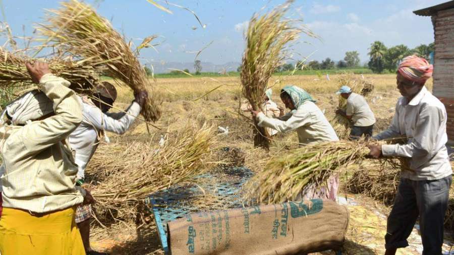
With expectations of a good monsoon, India that emerged as the largest supplier to rice in the world in 2020-21 is once again looking at an expanded production of paddy, reports Mahua Venkatesh
The damaging cyclone Yaas, which brought life to a standstill in several eastern states including West Bengal and Odisha just last month has also brought cheer to many just ahead of the rice sowing season.
While the cyclone damaged many crops, the rice growers are not complaining.
Ram Sakal Mandal, a farmer in Bihar’s Madhubani district said that the residual rains that followed Yaas has helped the soil gather moisture.
“The rice growers start their preparation for the crop from May end- June and the exercise essentially involves soil treatment for sowing the seed. This time, the rains led to the required moisture in soil and a lot of manual labour that is otherwise needed to prepare for the crop was not required,” Mandal said.
With expectations of a good monsoon, India that emerged as the largest supplier to rice in the world in 2020-21 is once again looking at an expanded production of paddy.
Production of rice and other field crops�crops other than vegetables and fruits�is also rising amid the Covid 19 pandemic as many farmers are moving away from growing perishable items. Rice contributes more than 35 per cent of the country’s total food grain production.
“We have seen many farmers opting to grow field crops which are more enduring than vegetables. While this may create some demand supply mismatch for a certain kind of vegetables, overall it ensures ample supply of food grain,” Venkatram Vasantavada, Managing Director & CEO, SeedWorks International Pvt Ltd told India Narrative.
Analysts said that the gloom that came with the severe second Covid 19 wave is fast disappearing.
Also read: Centre and states must focus on containing Covid 19 in rural sector ahead of Kharif sowing season
“Covid 2 had not just hit the urban areas but the rural sector was badly impacted too, giving rise to anxiety and fear. However, things have now started to look up from May 15 onwards, as the number of infected cases has come down, Vasantavada added.
The main rice producing states in India are West Bengal, Uttar Pradesh, Andhra Pradesh, Punjab, Tamil Nadu among others.
Earlier in an interview to the Financial Express, D.V. Prasad, chairman of the public sector Food Corporation of India�that deals with the public food distribution programme — said that “there is absolutely no need to worry as far as the availability of wheat and rice is concerned in any part of the country.”
Agriculture and its allied sectors continue to remain the largest source of livelihoods in India.
Meanwhile, policymakers said that the district level authorities have already swung into action to provide the necessary aid to those engaged in the agriculture sector.
MHA team to assess damage
Union Home Ministry will send a team to West Bengal on a three-day trip to review the impact of Cyclone ‘Yaas’, which affected the region in May end, sources said on Sunday.
The team, including a Joint Director-level official, will hold meetings with officials of Disaster Management and Finance Department in Nabanna, and visit cyclone affected areas in South 24 Parganas and East Midnapore, said a source in the Central government.
Yaas, which made landfall between Dhamra and Balasore in Odisha on early May 26, led to light to moderate rainfall at most places with heavy to very heavy rainfall at isolated places over Medinipur, Jhargram and Bankura in West Bengal.
The cyclone had affected Odisha as well as Jharkhand, Andhra Pradesh, Tamil Nadu and Andaman and Nicobar Islands. As the cyclone hit, rainfall in the region had led to inundation of low-lying areas.
Prime Minister Narendra Modi also visited Odisha and West Bengal last month and reviewed the impact of Cyclone Yaas.
The National Disaster Response Force (NDRF) said it rescued hundreds of stranded people in the state of West Bengal after the cyclone hit the region. (Indianarrative/IANS)
Gauba also stressed that safety of Covid patients be ensured and disruption of functioning of Covid hospitals and centres avoided…reports Asian Lite News.
With cyclonic storm ‘Yaas’ expected to reach West Bengal and adjoining northern Odisha coasts by May 26 evening, Cabinet Secretary Rajiv Gauba has emphasised that all measures should be taken in a timely manner to minimise loss of lives and destruction of property.
Reviewing the preparedness of central and state agencies during the National Crisis Management Committee (NCMC) meeting, Gauba further emphasised on the early evacuation of people from the areas likely to be affected by the cyclone along with ensuring the return of all boats and vessels to the shores, so that there is zero loss of life.
Gauba also stressed that safety of Covid patients be ensured and disruption of functioning of Covid hospitals and centres avoided. He also advised that steps be taken to maintain the generation and movement of oxygen from the cyclone affected areas, to other parts of the country.
The officer also said that preparatory arrangements should be made to restore power, telecom and other important services and directed the concerned agencies to work in close co-ordination and extend all requisite assistance to the states and the Union Territories (UTs).
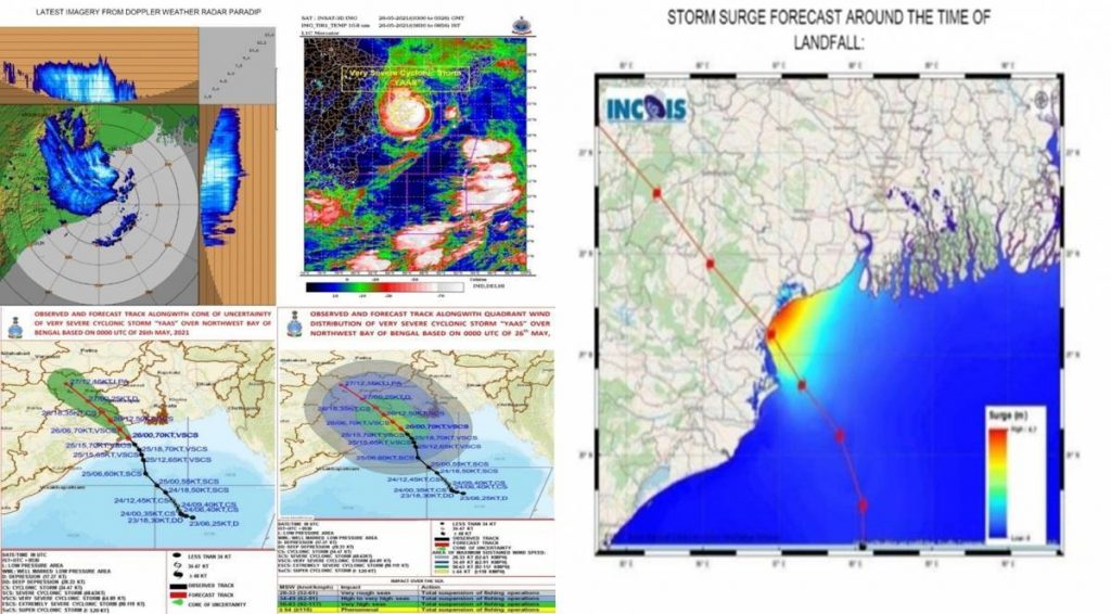
Director General of the India Meteorological Department (IMD) Mrutyunjay Mohapatra briefed the committee that the cyclone is expected to reach the West Bengal and adjoining northern Odisha coasts by the evening of May 26, with wind speeds ranging from 155 to 165 kmph, accompanied by heavy rainfall and storm surges in the coastal districts of these states.
Chief Secretaries of the concerned states apprised the committee of the preparatory measures put in place to deal with the cyclonic storm.
Evacuation of people from the low-lying areas is being carried out. Adequate stocks of foodgrains, drinking water and other essential supplies have been arranged and preparations made to maintain essential services such as Power and Telecommunications, the Chief Secretaries informed during NCMC meeting.
The Prime Minister, Shri Narendra Modi making an aerial survey of areas of Gujarat and Diu affected by Cyclone Tauktae on May 19, 2021. (PIB)
National Disaster Response Force (NDRF) Director General informed that the force’s 65 teams are deployed, and 20 more teams are on standby. Rescue and relief teams of the Army, Navy and Coast Guard along with ships and aircrafts have also been deployed.
Necessary arrangements are also being made to ensure uninterrupted functioning of hospitals and Covid Care Centres, alongwith ensuring generation and supply of oxygen to Covid facilities across the country.
The meeting was attended by Chief Secretaries and officers of West Bengal, Odisha, Tamil Nadu, Andhra Pradesh, Andaman and Nicobar and Puducherry. Secretaries of Ministries of Home, Power, Shipping, Telecom, Petroleum & Natural Gas, Civil Aviation, Fisheries, Chairman Railway Board, Member Secretary NDMA, Chief IDS and DGs of Coast Guard, NDRF and IMD also participated in the meeting.